


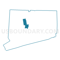
Bristol, Southington & Burlington Towns PUMA, Connecticut
About
Outline

Summary
| Unique Area Identifier | 192510 |
| Name | Bristol, Southington & Burlington Towns PUMA |
| State | Connecticut |
| Area (square miles) | 93.86 |
| Land Area (square miles) | 92.06 |
| Water Area (square miles) | 1.80 |
| % of Land Area | 98.08 |
| % of Water Area | 1.92 |
| Latitude of the Internal Point | 41.67612250 |
| Longtitude of the Internal Point | -72.92498380 |
Maps
Graphs
Select a template below for downloading or customizing gragh for Bristol, Southington & Burlington Towns PUMA, Connecticut


Neighbors
Neighoring Public Use Microdata Area (by Name) Neighboring Public Use Microdata Area on the Map
- Litchfield County PUMA, CT
- Meriden, Wallingford & North Haven Towns PUMA, CT
- New Britain, Berlin & Plainville Towns PUMA, CT
- New Haven County (Northwest) PUMA, CT
- West Hartford, Farmington, Simsbury, Bloomfield, Avon & Canton Towns PUMA, CT
Top 10 Neighboring County (by Population) Neighboring County on the Map
Top 10 Neighboring County Subdivision (by Population) Neighboring County Subdivision on the Map
- New Britain town, Hartford County, CT (73,206)
- Meriden town, New Haven County, CT (60,868)
- Bristol town, Hartford County, CT (60,477)
- Southington town, Hartford County, CT (43,069)
- Cheshire town, New Haven County, CT (29,261)
- Farmington town, Hartford County, CT (25,340)
- Berlin town, Hartford County, CT (19,866)
- Avon town, Hartford County, CT (18,098)
- Plainville town, Hartford County, CT (17,716)
- Wolcott town, New Haven County, CT (16,680)
Top 10 Neighboring Place (by Population) Neighboring Place on the Map
- New Britain city, CT (73,206)
- Meriden city, CT (60,868)
- Bristol city, CT (60,477)
- Terryville CDP, CT (5,387)
- Collinsville CDP, CT (3,746)
Top 10 Neighboring Elementary School District (by Population) Neighboring Elementary School District on the Map
Top 10 Neighboring Secondary School District (by Population) Neighboring Secondary School District on the Map
Top 10 Neighboring Unified School District (by Population) Neighboring Unified School District on the Map
- New Britain School District, CT (73,206)
- Meriden School District, CT (60,868)
- Bristol School District, CT (60,477)
- Southington School District, CT (43,069)
- Cheshire School District, CT (29,261)
- Farmington School District, CT (25,340)
- Berlin School District, CT (19,866)
- Avon School District, CT (18,098)
- Plainville School District, CT (17,716)
- Wolcott School District, CT (16,680)
Top 10 Neighboring State Legislative District Lower Chamber (by Population) Neighboring State Legislative District Lower Chamber on the Map
- State House District 17, CT (25,082)
- State House District 76, CT (24,317)
- State House District 80, CT (24,200)
- State House District 78, CT (24,163)
- State House District 79, CT (23,980)
- State House District 83, CT (23,874)
- State House District 30, CT (23,809)
- State House District 62, CT (23,806)
- State House District 24, CT (23,696)
- State House District 22, CT (23,430)
Top 10 Neighboring State Legislative District Upper Chamber (by Population) Neighboring State Legislative District Upper Chamber on the Map
- State Senate District 16, CT (105,218)
- State Senate District 13, CT (101,659)
- State Senate District 5, CT (98,818)
- State Senate District 8, CT (98,790)
- State Senate District 6, CT (96,421)
- State Senate District 31, CT (92,821)
Top 10 Neighboring 111th Congressional District (by Population) Neighboring 111th Congressional District on the Map
Top 10 Neighboring Census Tract (by Population) Neighboring Census Tract on the Map
- Census Tract 4058, Hartford County, CT (7,388)
- Census Tract 4056, Hartford County, CT (7,222)
- Census Tract 3061, Litchfield County, CT (6,970)
- Census Tract 4003, Hartford County, CT (6,902)
- Census Tract 4305, Hartford County, CT (6,547)
- Census Tract 3611, New Haven County, CT (6,503)
- Census Tract 3432, New Haven County, CT (6,249)
- Census Tract 4053, Hartford County, CT (6,140)
- Census Tract 4602.04, Hartford County, CT (5,941)
- Census Tract 4206, Hartford County, CT (5,880)
Top 10 Neighboring 5-Digit ZIP Code Tabulation Area (by Population) Neighboring 5-Digit ZIP Code Tabulation Area on the Map
- 06010, CT (60,448)
- 06489, CT (32,067)
- 06410, CT (29,161)
- 06451, CT (24,419)
- 06037, CT (18,565)
- 06001, CT (18,385)
- 06062, CT (17,715)
- 06032, CT (17,675)
- 06716, CT (16,680)
- 06479, CT (10,431)